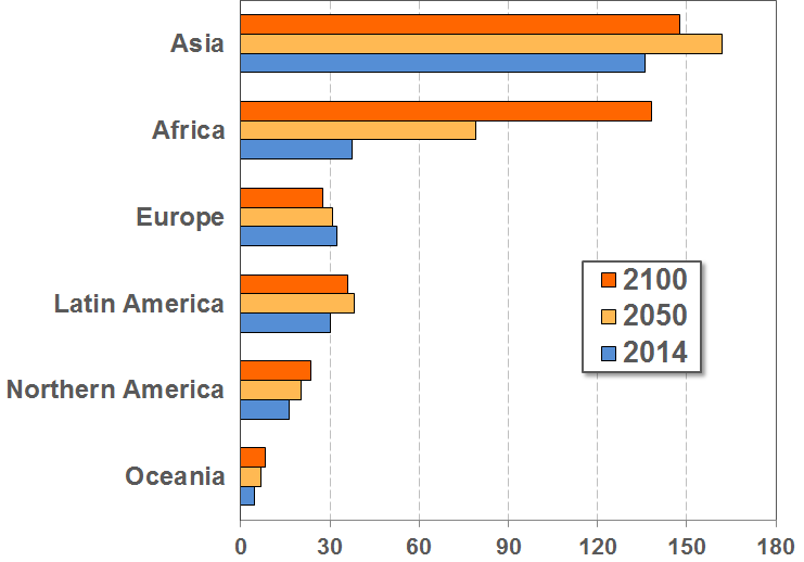
Africa is already more densely populated than Europe - if one includes the Russian Federation in Europe. This may surprise people who imagine Africa as an "empty continent". But Africa includes large inhabitable, and almost unhinhabited areas, such as the Sahara or the tropical rainforests.
By the end of the century, Europe may be more sparsely populated than Latin America and the Caribbean - due to Europe's projected population decline.
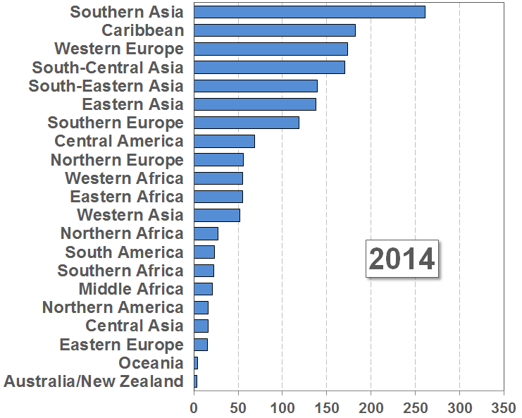
However, huge differences in population density exist within these regions. See next slides.
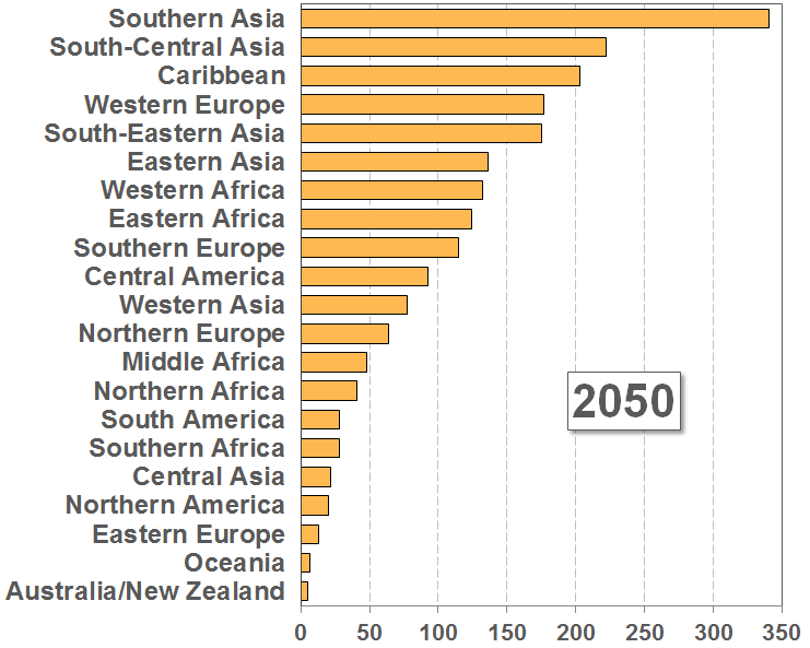
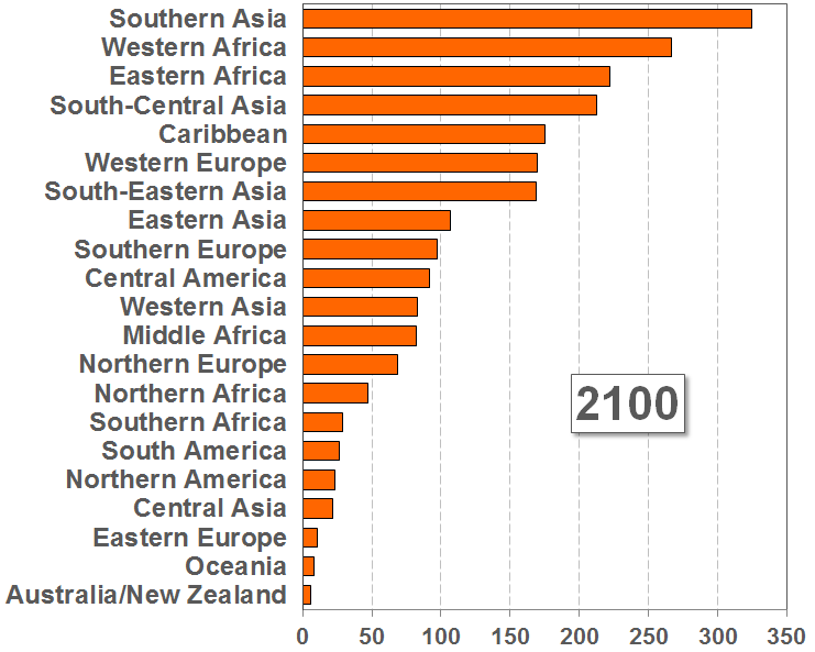
Eastern Europe, Oceania and Australia / New Zealand are, by far, the most sparsely populated sub-regions. Most likely, this will not change over the next 90 years.
By 2050, Western Europe will no longer be one of the top three most densely populated sub-regions. Instead, South Central Asia (primarily due to India) will "move up" to the position of the second most densely populated sub-region.
By the end of the century, Southern Asia, Western Africa and Eastern Africa will probably be the most densely populated sub-regions in the world.
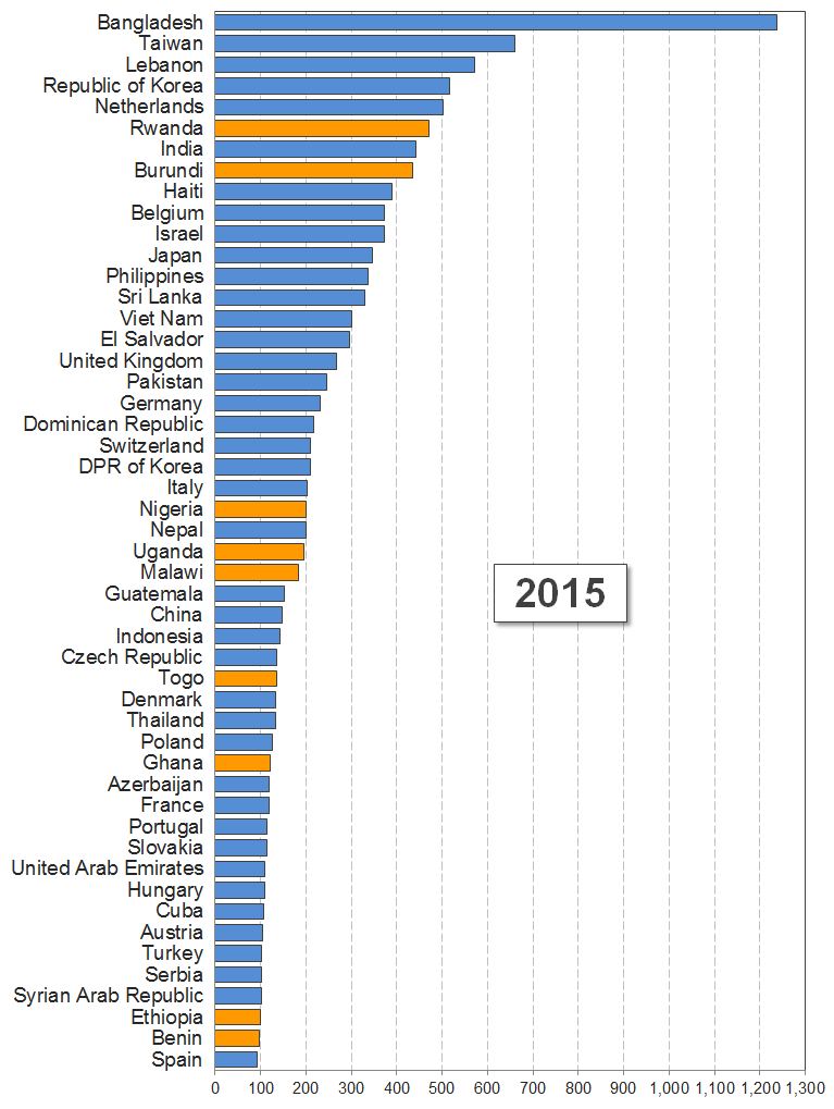
Top of the list are Asian countries, such as the Republic of Korea, Taiwan, or Bangladesh,- with population densities ranging between 517 and 1237 people per square km.
However, we also find two African countries, Burundi and Rwanda, with a high popopulation densities of around 435 to 470 people per square km. This population density is comparable to that of India, which is around 440 people per square km.
Afrika's most populous country, Nigeria, already as a population density of around 200 people per square km - which is very similar to that of Italy with a density of 204 people per square km.
It is also interesting that both Uganda and Malawi have population densities, which are higher than that of China - 195 and 183, as compared to 147.
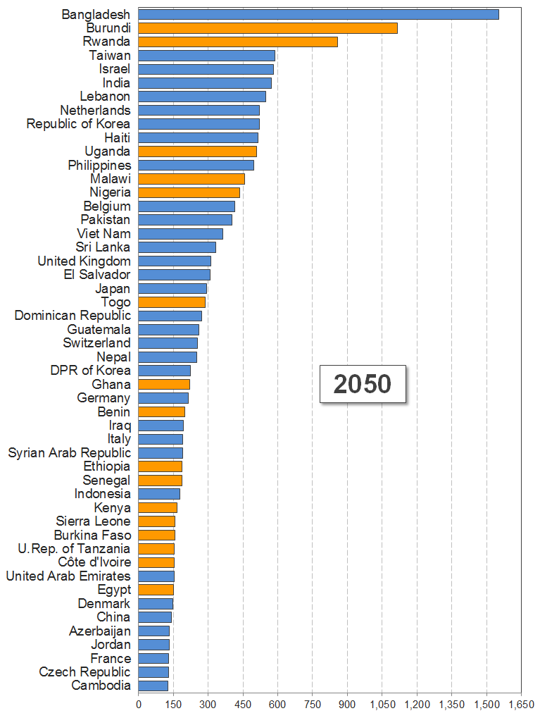
In fact, two African countries, Burundi and Rwanda, are projected to be the second and third most densely populated areas in the world (if we exclude the city states of Hong Kong and Singapore). Their population density will be 859 and 1116 people per square km, respectively.
Nigeria, Malawi and Uganda are projected to have population densities of between 438 and 510 people per square km - roughly similar to the Philippines, with a projected population density of 497 people per square km.
It is also interesting to note that Ghana and Benin will have almost identical population densities as Germany - 200 to 220 people per square km.
The enormous population growth in Africa will also result in the situation, that Kenia, Sierra Leone, Burkina Faso, Tanzania, Côte d'Ivoire and Egypt will all have a higher population density than Denmark, China or France.
United Nations (2011): Population Distribution, Urbanization, Internal Migration and Development: An International Perspective. Department of Economic and Social Affairs, Population Division.
Cohen, Joel E. / Small, Christopher (1998): Hypsographic demography: The distribution of human population by altitude. In: Proc. Natl. Acad. Sci., Vol. 95, pp. 14009–14014, November 1998 Applied Physical Sciences, Social Sciences.
CIESIN (2005): Mapping global urban and rural population distributions Estimates of future global population distribution to 2015. Database and maps prepared as part of the FAO Poverty Mapping Project (GCP/INT/761/NOR) funded by the Government of Norway and also with the support from National Aeronautics and Space Administration (Contract NAS5-03117) to the Socioeconomic Data and Applications Center (SEDAC) at CIESIN.
Firebaugh, G. 1982 Population density and fertility in 22 Indian villages. Demography 19, 481–494.
Leet, D. R. (1977): Interrelations of population density, urbanization, literacy, and fertility. Explor. Econ. Hist. 14, 388–401.
